Range maps added for Malacothamnus taxa
While it can be tricky to identify some Malacothamnus due to lots of overlapping morphological characters in the keys, most don't overlap geographically. If you are in an area where only one taxon is known, you can usually be pretty sure of the ID based on that, assuming that it is a wild plant and wasn't introduced in a restoration project. If only two or three taxa grow in that area, that also helps narrow down the possibilities. To address this, I've uploaded rough ranges of Malacothamnus taxa to iNaturalist. These will be updated with improved maps as this project progresses.
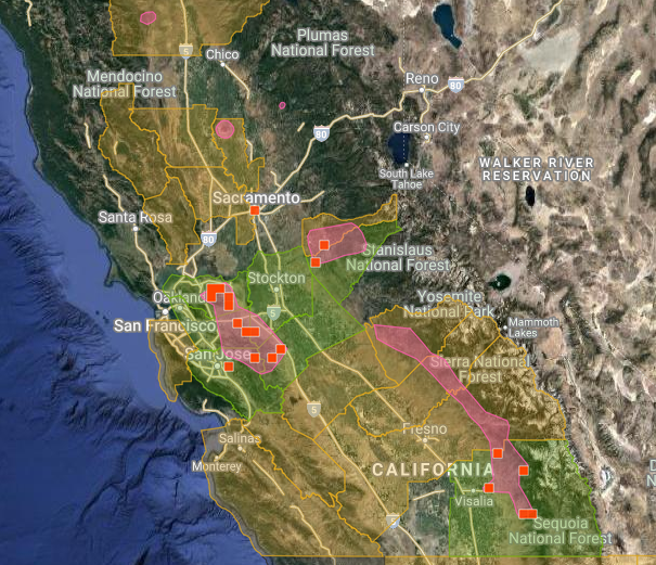
The image above is the range map of M. fremontii, which you can view an interactive version of here. The pink is the range I have uploaded, the green are counties where there are iNaturalist observations, and the orange is where someone put it on a list for a county where it may or may not actually occur. Malacothamnus orbiculatus has often been confused with M. fremontii and sometimes lumped into it. Compare its range here or on the map below and you'll see there is only a small area where they overlap and likely intergrade/hybridize (near the "S" in "Sequoia National Forest").
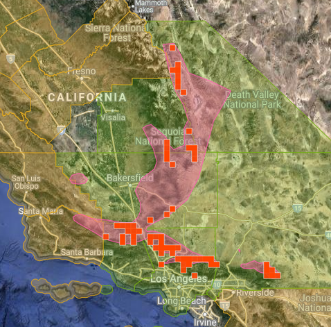
iNaturalist observation maps can get pretty messy for rare plants as iNaturalist obscures the coordinates. This is a very good thing for some species that really need that protection but a one-size-fits-all approach to the 1000+ rare plant species in California is more of an impediment to conservation for most (see views on that debate here). A rough range map doesn't give exact locations but does give you a better idea of where something may occur. See the range map of M. palmeri here and below. Once again, the two larger pink polygons is the known range. All the smaller circles of a similar color are obscured iNaturalist observations. Not a single one is in the known range of the species and most would have you believe this shrub is an ocean dwelling organism.

Many people have shared their coordinates with this project, which has been useful in making these rough range maps. This data will be used in creating better maps for the new treatment of the full genus I'm working on as well as for conservation assessments. There are many people out there that have observations with obscured coordinates that have not shared them with this project. I will tag all these people below. If you are one of them and would like to contribute plant locations to this project, see the instructions here to share your coordinates with the project. Thanks to all who have and will contribute!
Update Feb. 2023 - I have removed tags to people that had obscured coordinates as I'm mostly done with this research and many of the Malacothamnus taxa that were originally obscured on iNaturalist are no longer. Thanks to all who have helped with this project!


Comentarios
Thank you for creating such an interesting project and for sharing your research.
I joined so you have access to coordinates and hope to contribute many more Bush Mallow observations.
Great work on the range maps! Thought I had already shared my coords with the project long ago. Just followed the instructions and mine should be shared now.
Done! Thanks!
Thx, Keir. I have become a member of your project and have allowed anyone to add the coordinates of my observation. Hope that's right.
Thanks for the note, I'm happy to share the obscured coordinates. I don't make it to California very often, otherwise I'd keep an active eye out in case I see any more. I'm afraid I only have 1 observation to contribute, but I hope its helpful!
(The photos in this post aren't working for me at the moment, but that might be on my end)
I now see locations for all who commented so far. Thanks!
@erininmd Someone commented about that issue on another post. It basically comes down to your browser settings. If the security settings are super-high, they might not accept photos linked here from my website.
Keir, I followed your directions, so hopefully, you can see the exact coordinates of my observation of M. halli (your ID; Seek’s ID was M. fasciculatus) in Santa Theresa CP on 5/22/21. I saw several plants along the fence on the uphill side of the trail.
@hllrnnr Thanks! Yeah, Seek is a good starting place for IDs but ignores all the species that it doesn't have enough observations to make a predictive model of. So, it will ID many rarer species to more common species that are similar.
@keirmorse I just allowed curator access for my one M. hallii observation.
thanks for tagging me! I've joined the project and shared my obscured coordinatres with you.
Very cool! I'll keep an eye out on my next trip
I appreciate the tag and will add your project as trusted. I'll also try to be better at recording these when I encounter them. Really excellent work and very helpful.
Hi Keir,
The coordinates of my record for Malacothamnus hallii at Mt. Diablo, https://www.inaturalist.org/observations/77993943, are probably within about 30 ft of the actual population. These were the coordinates on my phone, but I don’t remember if I took them at the roadside or at the shrub which is about 25 or 30 ft. north of the road. There were 3 shrubs there. They are hiding behind the only walnut tree along Northgate Road, about 2 miles in from the NorthGate entrance kiosk. Here’s my description: “Mt. Diablo: About 2 mi from entrance kiosk where chaparral first begins along Northgate Road just beyond a rock outcrop. Not visible from road because it is hiding behind brush and a walnut tree”. (Note: the walnut tree isn't very big)
BTW, if you are looking for more data about Malacothamnus in the East Bay, you can sign up to access our CNPS East Bay Chapter Rare and Unusual Plants Database at our Chapter website ebcnps.org. (“Unusual” plants, btw, refers to our locally rare plants.) Click on the Conservation Science tab and you’ll see the choice for the database.
Dianne Lake, Unusual Plants Coordinater, CNPS East Bay Chapter
@diannelake Thanks! Is everything in the East Bay database on CNDDB? I have access to that. If not, sounds like I should check it out.
Agregar un comentario